Prepared by
M. Drake Patten
Department of Anthropology
University of Virginia
This report details archaeological survey work conducted on July 22, 1995 at the Stanton Family Home site in Buckingham County, Virginia. The survey was accomplished through the volunteer services of the Venable Lane Archaeological Field Seminar from the University of Virginia, under the directorship of the author, M. Drake Patten.
The main purpose of this survey was to establish whether future archaeological work at the 19th century African American home site would be viable and/or productive. The work was carried out at the request of Renee Ingram. Ms. Ingram is a Stanton family descendent and the major force behind a successful application for landmark status for the nearby family cemetery. Ms. Ingram hopes to seek funding for future work on her family's domestic complex, most of which is no longer standing.
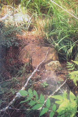
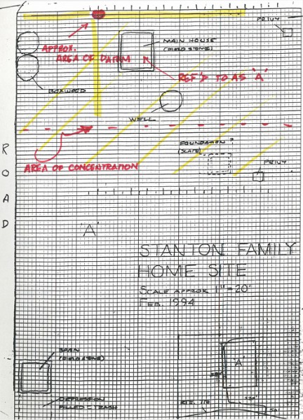
 In February of 1994, archaeologist David K. Hazzard conducted a site inspection in the company of Renee Ingram. Hazzard found the site to possess good archaeological potential (Appendix 1), although the family recalled the dismantling of most of the standing structures and subsequent vandalizing. In 1994, Hazzard noted the presence of two foundations, house and barn, as well as, evidence of an additional structure. He also noted presence of a well and at least three privy shafts (Figure 1).
This archaeologist's connection with the project began not long after. Early conversations with Ms. Ingram revolved around the monitoring of preservation and landscaping of the nearby family gravesite. The archaeological concern was with establishing the possibility of unmarked graves existing beyond the obvious marked delimits of the cemetery, and in negotiating a way to insure that new plantings and general preservation attempts at the cemetery would not impact known burials.1
Background research conducted for the purpose of the cemetery nomination details a rich and significant story of rural African American life, not only related to the family, but to the wider social and economic details of 19th century Buckingham County and the larger Virginian historical landscape. To date, very few "free black" rural sites have been studied-- archaeologically, historically, or architecturally - the Stanton home site could prove an invaluable opportunity to build on this woefully limited understanding.2
 Although my initial plan was to provide Ms. Ingram with a two day survey with the assistance of students from a University of Virginia field seminar class, the tremendous area flooding in June of 1995 caused us to reschedule once in June, and then again due to the subsequent rain and resultant schedule conflicts in July. In the end we were only able to offer Ms. Ingram one day of survey in July. The team was also largely made up of novice excavators. Due to these reasons, I feel that we accomplished far less than planned, and some of the decisions I outlined below were the necessary result of these limitations.
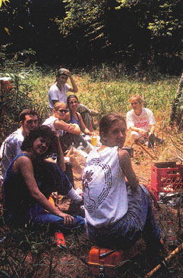
Survey of the Stanton home site was conducted under the direction of M. Drake Patten, director of Archaeological Venable Lane: The Foster Home site and a Phd Candidate in Anthropology. Assisting in this survey were staff archaeologists Jillian Galle and Lahela Perry. Seminar students Brad Eldridge, Julia Kasprzak, Dorothy Overpeck and Shannon Wright and Monticello staff archaeologist Allison Tillack acted as the survey team. All members of the team are students at the University of Virginia.
 Our goals were to map the area and conduct as extensive a survey as possible in the areas already identified by Hazzard. As mentioned, our initial survey time was substantially shortened and I decided to limit our work to placing a series of shovel test pits (hereafter STP) along a north-south, east-west directional axis from an arbitrary3 grid point established with 1.5" reebar (Figure 2). The majority of the STPs were placed in the northeast quadrant, the area with the most extant structural evidence. The decision to concentrate on this general area was made due to the lack of manpower, time constraints, and the severe overgrowth that existed beyond the area cleared in preparation for our arrival. To conduct a full survey, we would have needed more time and people: both to cover more ground and to clear the severe undergrowth and presence of hornets across much of the property4. I also chose not to map the extant foundations and pits, my rationale being that a mapping of these structures could be easily achieved at any point in the fall or spring, with less growth and using the permanent datum point we would establish.
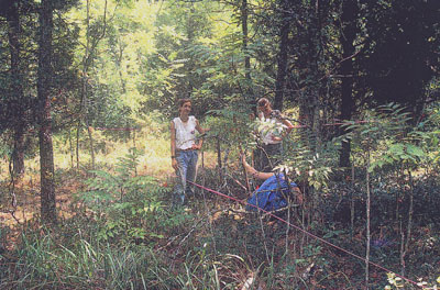
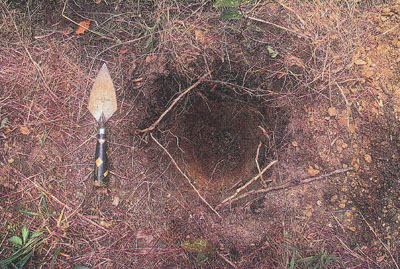 A total of twelve STPs (Figure 3) were dug along an east-west and north-south axis from datum at 10' and 20' intervals. An additional eighteen were dug on the same grid, but placed in the northeast quadrant of the grid, at variable intervals. Numbers were assigned chronologically (in order of excavation). Most of the STPs we opened are within the area which we will define here as the 'domestic complex.' This area was delineated partly by the extent of bush-hogging done in preparation for our arrival and partly as a result of Mr. Hazzard's observations. Our datum point was established in the center of what appeared to be a road bed leading along the western wall of the stone foundation previously identified by Hazzard (Figure 4). The datum was thus established in order to insure our ability to return and fully map the extent foundations, as well as, for future archaeologists to be able to continue archaeological work along the same axis.
"YARD" STPs5:
STP 1-7 (Figure 5)
Level A: black loam with slate fragments
Level B: light grey sandy loam
Level C: light yellow sandy loam
Subsoil was a compact red clay and appeared circa .5 feet from grade. Levels A-C appeared to thin out in a southward direction.
Artifacts6
| STP# | Level A | Level B | Level C |
| 1 | na | na | na |
| 2 | fence wire | na | na |
| 3 | na | local stoneware | bottle gls |
| 4 | na | na | na |
| 5 | na | window gls cut nail | na |
| 6 | na | na | na |
| 7 | na | na | na |
STP 8-12
Level A: black loam, circa .3' deep
Level B: grey/tan sandy loam, circa .9" deep
Subsoil was a compact red clay and appeared circa 1.3-1.5' from grade.
Artifacts
| STP# | Level A | Level B |
| 8 | na | na |
| 9 | na | gls vessel |
| 10 | na | na |
| 11 | na | refined white earthenware horseshoe |
| 12 | na | na |
'FEATURES' STPs
STP #13, 13.1, 17, 18, 19, 20, 26

 These tests were placed to test areas of extant structure.
STP 13 and 13.17
13 was along the north-south wall of the probable house foundation (hereafter A, Figure 6) and was basically made up of the rocks from the foundation line, thus revealing no discernable layers. No artifacts were recovered, although fragments of mortar were collected. 13.1 was within the foundation area, again no artifacts were recovered although like 13, stone and mortar were in high concentrations, presumably fall in from the house structure.
STP 17
This test was placed halfway between the west and east corners of the northern wall (exterior) of Structure A. Three layers were visible, and the stratigraphy was as seen in STPs 8-12. Window glass was recovered in Levels B and C, and clear vessel glass was recovered from Level C.
STP 18
This test was located halfway between the west and east corners of the northern wall (interior) of Structure A. Stratigraphy consisted of a black loam topsoil (A) and a grey tan loam as B. Level B contained a piece of clear vessel glass.
STP 19
This test and STP 20 moved to the southern wall of Structure A. STP 19 was located halfway between the west and east corners of the southern wall, along the exterior. It had two discreet levels. Level A was a black loam and B was a grey yellow sandy loam with what appeared to be some intermixed red clay. This level contained a cut timber nail and a piece of clear vessel glass.
STP 20
This test was placed exactly as STP 19, but along the interior of the foundation wall. Stratigraphy was not noted, probably due to a large tree disturbance. Window glass was recovered from Level A (arbitrarily recognized and assigned).
STP 26
This test ran along the edge of the feature described also by Hazzard in his 93 document. This team believes this may be an icehouse. Two layers were noted. Level A was a dark brown topsoil and Level B was a dark grey loam.
Level A iron pulley (c. 2" diameter) unidentified chromed
metal object machine molded, octagonal "MOROLINE" jar
Level B white refined earthenware, saucer fragment plastic cap washer
STP 21-23, 25, 27-30,
Level A: dark brown loam
Level B: dark grey loam
Level C: sandy loam with notable charcoal inclusions
Subsoil was compact red clay with charcoal stains along interface,
appearing circa 1.35' from grade.
| STP# | Level A | Level B | Level C |
| 21 | na | na | na |
| 22 | na | na | na |
| 23 | leather boot heel | glass vessel (appears to be the edge of a post hole) |
|
| 25 | slated noted | machine mold jar | |
| 27 | Boyd's liner | refined white earthenware saucer, beaded rim plate (fence line runs here) |
|
| 28 | na | na | na |
| 29 | na | window glass bristol glazed stoneware |
na |
| 30 | slated noted | na | na |
STP 24
Level A-C as seen in above section, with the addition of a possible Level D. Like the layers above, the interface with sub was charcoal stained, only notably so, and the possibility exists that this was another layer. This test was arbitrarily closed due to time. This test may well be hitting the edge of a post hole. A wood sample was taken.
DISCUSSION AND IDEAS ABOUT THE HOMESITE
What follows is both a reaction to the material recovered and to my own experience walking the site both this summer and in the past. It is a fairly informal assessment of the date at hand, as well as, a reflection of 19th century landscapes, structural complexes and material culture.
The stratigraphy proved universally simple across the area tested with no obvious indication of disturbance from plowing or other agricultural activity8. All of our investigation was limited to the "domestic complex" as it was defined by Hazzard and the survey team. Adding to Hazzard's initial observations of the home site, I noted the presence of additional cultivated landscape features, which helped to guide our decision of where to place our initial survey grid. Burnt organics on the interface of tests sunk north of Structure A may be the result of the initial land clearing that took place to build and farm the land. The relatively thin deposition of cultural layers across the site is somewhat puzzling, but with no signs of recent disturbance, (agricultural or otherwise, it may be a sign of a relatively "clean" yard, suggesting that the trash was disposed of beyond the periphery of the house complex, or at least to its edges. STP 25, for example may suggest the latter scenario, since it is located along what appears to be the north/south roadway fence.
The overall concentration of the 19th century domestic artifacts9 is restricted to the interior of the northeast survey quadrant. This is not surprising, considering that this is both the area of our heaviest investigation and the area of extant structures. On the other hand, there is a notable absence of artifacts of any kind in the STPs dug in the southwest quadrant, further supporting the idea that the area is relatively undisturbed, and that the northeast quadrant was used in a very different way than its neighbors. In addition, the area between the northern wall of structure A and privy shafts (Figure 7) contained the most complicated of the stratigraphy noted. Likewise, the area near the possible well/icehouse, although minimally tested, looks promising as a trash.
deposit, likely from the complex's dismantling, but possibly earlier. Although none of the possible privy shafts were tested, their use as localized trash receptacles (as new shafts were dug) would not be unexpected.
It may be possible to place their disuse and filling in some sort of seriation: possibly showing trash patterns from the complex's occupation. This would be of interest since it is possible to trace micro-events (such as a marriage, a death or other household-based occurrence, as well as, macro-events, such as the impact of war or market fluctuation on the larger economy)--through the examination of material culture. Just from this survey alone, we can suggest the physical limitations of at least one period of the domestic complex (the north-south fence line ad road). Future questions could include: Did the domestic area change its size/shape/focus over the period of occupation? If so, how and why? What can the material culture tell us about the supply available to a rural "free black" household? What kind of impact did the use of the land have on the domestic area? Is evidence of this interaction available in the ground? How did the landscape beyond the fence and the road appear? Was the fence a "real" barrier--needed to keep animals out of the domestic area--or was it to delineate private property from public land? Questions should also be asked of the land beyond the immediate area of survey to date. According to documentary research, the Stanton farm, at least in its second-generation usage, was much more than subsistence or even small-scale farming. It would be of value to determine the layout of the fields, and the location of the barns (one at least is already probably located near the domestic complex defined in this document). The farm's position vis a vis the Civil War and the subsequent changes to the local economy after the Union army's destruction of the Canal would be of interest to the local area, since the results of these events were undoubtedly shared by many of the area farms. Agricultural and domestic plants could be investigated with the aid of pollen and plytolith analyses.
It seems clear to me that the home site would be both a viable and a productive archaeological research project. The notably paucity of excavated rural "free black" sites and the particulars of the Stanton family ownership of this land over a consecutive period of years makes this a desirable focus of research.
My advice to Ms. Ingram at this point is to seek either an interested graduate student who has enough experience to commit to and reach amount of conclusion with this project, or to seek a class, again related to an academic institution.
Neither of these solutions are speedy, but short of hiring an independent team they are the most cost-efficient, and I might suggest, information-efficient ways to go about this project. As Ms. Ingram and I have discussed, there is relatively little available in the way of funding for historical period sites, especially those related to 19th century life. On the other hand, as I have suggested above, there are compelling reasons why this site is worthy of study, and it certainly has the potential to dovetail nicely with the more popular target of 19th century studies into urban free black life. The latter retains no context without the former, as scholars are increasingly realizing. On the flip side of this, the Stanton home site is not currently a threatened resource and that in itself is both a help and a hindrance. The site's non-threatened status allows Ms. Ingram to create a research project that will fully cover her needs in a comprehensive way. At the same time it means that the site is not competitive for funds, which focus on protecting sites, which will otherwise be destroyed.
It is my opinion that the Stanton Family home site has tremendous promise not just because of our existing knowledge of the families rich personal history and its connection to the local agricultural and industrial communities, but because it would be an important addition to the paucity of information available regarding rural "free black life" in 19th century Virginia and the south generally very few such sites have been catalogued or excavated.
Based on the results of this survey, I encourage Ms. Ingram to undertake further study with the proviso that she seeks a both a long-term research commitment from an archaeologist or other researcher who can coordinate the project and insure its completion. Below, I suggest a plan for attack, which might be met by an academic connection and would involve a multi-disciplinary research team:
1) A larger survey conducted, aimed at assessing the true limits of the occupied area and establishing a reasonable land area to consider for further study.10
2) Based on the results of 1), an exhaustive documentary and ethnographic-- photographic, narrative, oral historical--survey to be conducted aimed as establishing both a direct and local context (temporal and spatial) for the Stanton home site.
3) Archaeological excavation to be conducted over multiple seasons and to involve consultation with architectural historians, landscape historians and local advisors. Research questions and project plans to be created with the help and advice of multiple consultants and the input of those involved in 1) and 2).
4) Dissemination of information through publication, visual record and public visitation.
[1] For more detailed information on this aspect of the Stanton family's preservation efforts, see the National Register of Historic Places form for "Stanton Family Cemetery" (DHR File No. 14-52).
[2] See Nomination, DHR File No. 14-52.
[3] This is the only arbitrary insofar as it is not on a larger map of the area. We selected a point, which seemed to relate to the most recent intended landscape, in this particular case, the roadway leading through the 'complex.' Since the landscape is largely a grown and decaying structural one, we had no permanent landmarks from which to work, thus the establishment of an arbitrary grid and the use of cardinal directions for our axis.
[4] The nature of STP survey is such that small teams with limited time resources run the risk of "missing" sites and artifact concentrations since they cannot adequately blanket the area under investigation.
[5] This arbitrary category recognizes the notice we took of extant structures and their opposition to the surrounding landscape and unused road beds.
[6] Some use of abbreviation is made, normally self-explanatory: "gls" is glass,
[7] 13.1 is not on the 1995 grid. This was incorrectly surveyed and begun before I came through taking notes. I chose to have the students finish this and 2 others also mis-surveyed. They were treated just as the STPs that were on the grid.
[8] Although not part of the survey area, a road bed, possibly or logging appears to cut along the western face of the complex.
[9] The few ceramic fragments, although not particularly diagnostic pieces in themselves are fairly typical of 19th century household, as is the Boyd's liner, probably post-1869 but pre 1900 and the various probable jars and bottles represented by the category "vessel." The MOROLINE is, I believe a Vaseline type of product, although as of this writing I have not been able to track it down.
[10] Due to the nature of our work I chose not to implement a walking survey, which would have ideally preceded our physical survey in "known" areas already established by Renee Ingram and David Hazzard. Thus, the results of this survey are not comprehensive, and as mentioned, were largely defined by known features and by the cleared area. Future work would undoubtedly profit from a comprehensive walking survey to possibly include all land from the original acreage which has reason to include residential and or agricultural evidence, with the possible physical landscape links between the family cemetery and the home site to be included.


The African American Heritage Preservation Foundation has partnered with several public and private sector entities throughout the past twenty-nine years. Our Preservation Partners have not only provided cooperative agreements and preservation grants, but also human capital - architects, educational staff, historians, preservationists, local leaders, college students and volunteers.
